Complexities of Ruvuma landscape and the scenario planning process
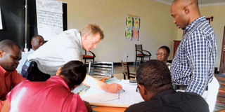
Participants in the scenario planning meeting for the Ruvuma landscape in a group work. PHOTOS | LUCAS LIGANGA
What you need to know:
- The Ruvuma landscape covers Ruvuma, Mtwara, Lindi and Morogoro regions in southern Tanzania and Niassa and Cabo Delgado provinces in northern Mozambique
Songea. “When we started this meeting three days ago people looked confused, frustrated and lost, but at the end of the meeting they felt informed and empowered,” said Mr Watson Nganiwa, assistant administrative secretary for economic and production sector in Ruvuma Region.
Mr Nganiwa made his observation at the end of a three-day meeting on scenario planning process for the Ruvuma landscape, a trans-frontier area of approximately 280,000 square kilometres flanking the Ruvuma River south of Tanzania and north of Mozambique, held at Heritage Cottage between December 12 and 14, last year.
The Ruvuma landscape covers Ruvuma, Mtwara, Lindi and Morogoro regions in southern Tanzania and Niassa and Cabo Delgado provinces in northern Mozambique.

The meeting took place against the backdrop of the Ruvuma landscape facing several development and conservation challenges, including the exploration and discoveries of natural gas and mineral deposits, proposed major development projects such as transport infrastructure, commercial agriculture, oil and gas exploration, forest plantations and biofuel production which, if not tackled carefully, could pose serious degradation of natural resources and the environment within the landscape.
The meeting brought together senior officials from regional governments of Ruvuma and Mtwara to carry out the initial scenario planning process that focused on the Ruvuma landscape and facilitated by WWF.
The process is involving government technical staff from each region, NGOs working in the natural resources sector from northern Mozambique and Tanzania and the private sector.
Due to such complexities of the Ruvuma landscape, the scenario planning process will build an understanding of the drivers of change in the landscape in order to underpin the current complexity of processes at a larger scale, said Mr Geoffrey Mwanjela, WWF Tanzania’s Coastal East Africa Global Initiative technical programme office.
Mr Mwanjela added: “The process will link between drivers of change and their implications for conservation initiatives and development efforts in the landscape and how the landscape stakeholders can work together to use the outcomes in designing intervention strategies.”
He said the meeting was important due to the transformation that the landscape is undergoing that could either lead to ecological and social degradation seen elsewhere in Africa.
“There is a need for a more secured future through an integrated development planning process that promotes the management and sustainable use of the unique natural resources and the resilience of the socio-ecological system of the landscape,” said Mr Mwanjela.
The Ruvuma regional administrative secretary, Mr Hassan Bendeyeko, said the scenario planning process will help identify future pathways of integrated development and mechanisms that will contribute to government planning processes for coping with uncertainty, identifying research needs, interventions and monitoring requirements.
The Mtwara acting regional administrative secretary, Mr Smythies Pangisa, said the scenario planning process was very important because the landscape was experiencing massive investment interests from many developed countries.
“These tools will be key to alert the government of the threats, drivers, plausible futures and solutions for various investments,” he said.
For example in Mtwara Region, Pangisa said, the regional authorities in collaboration with the National Development Corporation (NDC) recently commissioned three studies that looked at various options for natural gas utilisation in light of the establishment of gas-to-industry cluster in the Mtwara Development Corridor.
“While these studies may have come at the time when we do not have enough information on broader corridor and landscape, it is my hope that this scenario planning process will add value to the findings that the study will come up with,” said Mr Pangisa.
Mr Michael Murphree, regional coordinator for the African Centre for Disaster Studies at North West University in South Africa, said scenario planning was a tool, methodology or process for analysing the future in a creative and innovative way that challenges the mind to use past experience with current indicators and drivers to create plausible alternative futures. “It is about past, present and future,” he added.
Mr Murphree said scenario planning is useful for the Ruvuma landscape because it is a complex socio-ecological system with a wide range of emerging issues.
“Change is happening all over the landscape. How will the future look?” queried Mr Murphree, adding that the future always has shocks and surprises.
Writing for WWF, Mr Jacques Somda says in a booklet titled Biodiversity Conservation and Sustainable Development in the Ruvuma Landscape: A Vision Statement of the Greater Ruvuma Landscape that the Ruvuma landscape is one of the nine priority landscapes and the only trans-boundary where WWF through its Coastal East Africa Initiative (CEAI) intends to add value to its long term conservation work in the region.
He says this will be done through promoting initiatives that reduce pressure on natural resources, ensure the survival of globally important habitats, species and other natural assets to provide the foundation for sustainable economic growth.
In order to implement a successful conservation programme in such complex and dynamic biological, social, economic and political systems requires the development of common vision between the various stakeholders having interest in biodiversity conservation and economic development of the surrounding communities, says Mr Somda.
Mr Roberto Zolho, Ruvuma Landscape Coordinator for WWF Mozambique, likened the Ruvuma landscape to an ecological bank saying the area was home to the largest contiguous miombo woodland and associated ecosystems.
Mr Zolho added that 40 per cent of the landscape is under protected area, it has the second largest elephant population in Africa, it has extensive arable land, it has biodiversity rich coastal forest ecosystem but with poorly developed socio-economic infrastructure.
The scenario planning process meeting was indeed timely as Tanzania is poised to become a significant producer of natural gas in the wake of recent discoveries of world class reserves onshore and offshore Mtwara and Lindi regions.
Government sources privy to natural gas and oil discoveries say exploitation of natural gas reserves which currently stand at more than 43 trillion cubic feet (tcf) will provide Tanzania with a unique opportunity to catapult into a new orbit of growth and development and be able to achieve the sustainable socio-economic transformation with prosperity, espoused in the goals of the Tanzania Development Vision 2025.
However, the sources say, in order to domesticate the natural gas boom and achieve socio-economic transformation with sustainable growth which is inclusive, it is necessary to have in place a well-informed strategy for gas exploitation in terms of preparedness to host the new gas economy and to absorb the impact at all levels from national, regional to host communities.
Regional administration and local government authorities play the critical role of linking and integrating national plans and goals with regional and local socio-economic development plans which embody the aspirations of the people for inclusive growth, say government sources. Since the new gas economy will be developed in Tanzania, the country is challenged to create the prerequisite physical infrastructure, business infrastructure as well as institutional and human capacities to be able to host the gas economy.
The sources say the situation is most challenging considering the fact that Mtwara and Lindi regions are historically marginalised, and now they are at the centre of beehive activities of gas exploitation.
“The availability of natural gas is expected to motivate the development of energy intensive industries as well as industries which use gas as feedstock such as petrochemical industries,” say the sources.
However, the sources say Mtwara and Lindi regions have poor physical infrastructure and lack a business community with requisite capacities to provide services to the gas sector as a means of domesticating the benefits of gas exploitation.
Additionally, Mtwara and Lindi regions are steeped in traditional subsistence agriculture and hence there is no pool or a reserve of industrial labour which could be converted to skilled workers for the gas economy.
Equally, the rapid development and growth envisioned as a consequence of natural gas exploitation will result in related rapid population growth with consequent upward pressure on the demand for food, economic services infrastructure such as transport, communication, electricity, land, housing and water, say the sources.
In September 2006, the regional administrations and local governments of Mtwara and Ruvuma in Tanzania and the provincial governments of Cabo Delgado and Niassa in Mozambique signed a memorandum of understanding (MoU) aimed at promoting regional economic growth for the benefit of the people of the regions. In the MoU, authorities from both countries noted that there was great economic potential in agriculture, marine park, natural gas, tourism, transport and communication infrastructure in Mtwara and Ruvuma regions, and of Cabo Delgado and Niassa provinces.
Authorities in the two regions and provinces agreed to establish four government working groups to oversee economic, security, conservation, tourism and governance issues.
For example, the government working group for economic issues was tasked to oversee the establishment of transport infrastructure, improvement of Kilambo ferry on the Ruvuma River and finding alternative means of livelihood for people living adjacent to conservation areas.
The security working group is overseeing security and immigration issues, including curbing human trafficking, illegal possession of firearms and ammunitions, smuggling of goods and narcotic drugs, control of robbery and theft, illegal fishing and other criminal acts.
The environment and conservation working group is overseeing tourism and conservation issues, promotion of tourism in the Selous and Niassa Game Reserves in Tanzania and Mozambique, respectively, and overseeing land management through effective monitoring of mining operations to avoid environmental degradation caused by the use of mercury, and preventing agriculture and mining activities on river banks.
The public administration and good governance working groups are overseeing the sistership between Mtwara and Ruvuma on the Tanzanian side and Cabo Delgado and Niassa on the Mozambican side.
Indeed, the scenario planning process meeting held in Songea Municipality was timely as it tried not to predict about the future of the Ruvuma landscape but it tried to plan for the future of the landscape.
Participants in the meeting observed that the Ruvuma landscape was a complex issue because it involved a socio-ecological system with a wide range of emerging issues.
At the end of the three-day meeting the participants felt well-informed and empowered with most of them asking the question: “How do we reach by 2025 a Ruvuma landscape where the natural resources are resilient basis for equitable and sustainable development for its people?”
Mr Zolho called on the governments of Tanzania and Mozambique, donors and development partners to plan towards the sustainable development of the landscape.
“The meeting has been a great experience to us. Let’s keep this spirit of working together between the governments of Tanzania and Mozambique and their institutions in planning for the Ruvuma landscape. It is very possible,” said Mr Zolho.