Can roads/buildings at flood-prone Jangwani be elevated?
Morogoro Road in Dar es Salaam is a major gateway to Tanzania’s defacto business capital. It’s a major infrastructure of national importance. No wonder the Roads Act (2007) recognizes it - as part of TANZAM Highway and Central Corridor. We are talking about the road connecting the city and Dar es Salaam Port to our very important trading nations, some of which are landlocked.
Some researchers and policymakers see TANZAM Highway as one of the most important trunk roads in the country. So when you close any part of the highway, subsequent inconveniences are huge to city residents, there are economic losses to transporters, workers, tourist operators etc.
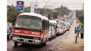
It’s an open secret that when Dar es Salaam experiences heavy rains- in some areas, all hell breaks loose. Some roads and bridges become impassable, some houses are flooded. On May 10, after heavy rains, some part of Morogoro Road became impassable. Vehicles from Mbezi to Ubungo, could not use the road. Then between Magomeni and Jangwani, the road was closed because it was heavily flooded. That day there were people who spent over 6 to 8 hours from Mbezi Luis to the city center, a journey that should have taken an hour or less.
Unfortunately, this is a story that has been repeating itself for years. Whenever it rains heavily, for example at the flood-prone Jangwani, it becomes a nightmare for both motorists and pedestrians. The big question is, why have we not searched for a permanent solution?
I was relieved to hear the Dar es Salaam Regional Commissioner, Mr. Paul Makonda, announce that plans were underway to solve the problem once and for all. For all intents and purposes, this was great news. They say, better late than never. The RC indicated that a group of experts was doing the initial designs. Hopefully, the plans will be made public and public participation sought.
Jangwani is part of Msimbazi River Valley in Dar es Salaam. If environmental engineers among other experts are involved in the project, methinks we can even have a Jangwani “city,” despite the area being a floodplain.
It’s possible to allow construction at Jangwani and for any building or road to have what experts call “above the 100-year floodplain elevation.” Though it will not be cheap, putting up buildings and roads to sit above flood water is very possible. Then there is the issue of ensuring the floodway is capable of carrying all moving water during the time of floods.
This would call for policymakers to introduce laws and regulations for floodplain standards. We need new rules which will compel those building houses, for example around Jangwani, to elevate up to as high as it will be designated by experts.
Methinks if Morogoro Road at Jangwani, or the building housing the Dar Rapid Transit (DART) project were elevated high enough, we would not be talking of the road being affected by the floods.
In the recent floods, it was estimated the over 500 houses in some areas in the city were submerged in water. New rules should set standards of how high must buildings in such areas be elevated.
It will not be an easy walk coming up with floodplain building elevation standards. Multi-agencies and experts are supposed to be involved, as it’s a highly technical exercise. It will be expensive but they say, where there is a will, there is always a way.
According to Dar RC, Jangwani will be improved under a huge infrastructure project financed by the World Bank. At the same time, when Akinwumi Adesina, the 8th President of the AfDB met President Magufuli, he promised the bank was going to partner with Tanzania in huge infrastructure projects. Hopefully, the Jangwani upgrade will happen soon and in the right way.