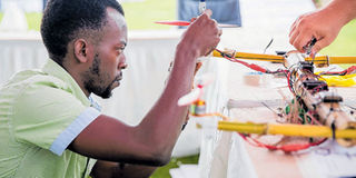
Bornlove Ntikha working on a drone made from bamboo. PHOTO I COURTESY
What you need to know:
Holding a Bachelor’s degree in Community Development Studies, this young graduate turned his interest into a profession
Bornlove Ntikha, 25, is proof of how young graduates in Tanzania and the rest of the globe have to be flexible and versatile in a highly competitive environment, but also one full of opportunities.
After graduating from Ardhi University with a bachelors in Community Development Studies in 2017, Bornlove joined Ramani Huria under the Humanitarian OpenStreetMap Team (HOT) in Tanzania. At Ramani Huria, Bornlove took on various roles from mapper to driving the organisation’s bajaj (tricycle). But Bornlove was attracted to mapping and enjoyed working with aerial views of Tanzania which had never before been mapped to such accuracy.
Whenever he wasn’t running errands for the team or dropping off and picking up other mappers, he used the opportunity to play around with the offices’ three Nano drones. Bornlove fell in love with the gadget so much that he wanted to learn how to make his own from scratch. Success met up with Bornlove to find out more about his love for drone making.
I work in the Technology and Innovation Department of HOT, where I mostly focus on drone building, deployment and capturing aerial images of Tanzania. Currently, I’m more focused on the drone construction part of the job. I became interested in constructing after I flew my first large drone, the 3DR Iris, it was more complex than the smaller drones I’d flown and I wanted to know how it worked and how I could build my own. Now I can say that drones are both my profession and my hobby.
What are you currently working on?
Well, at the moment I’m busy with a bit of paperwork. I want to dedicate all my time to aerial mapping and in order to do that I need to get government clearance. Tanzania, like many other countries, has made drone flying illegal unless given prior permission, so we are in the process of applying for permit. I am also busy building a mapping drone with a specialized camera mount for us to be able to collect visual data. Once we finish the drone and get the permit we will start mapping the outskirts of Dar es Salaam, in Bagamoyo.
How detailed will the mapping be?
It will be the most detailed imaging of the area that’s ever been produced. We will be able to map every household up to centimeter accuracy. All the mapping is open to the public and will be uploaded on OpenStreetMap website. The raw data will also be available on GeoNode, a geospatial content management site, for anyone to access and use in whatever way they want. This is what makes what we are doing different from Google Maps. Google owns the mapping data they collect which means that government and private companies or individuals cannot gain access to the data and use it in different ways such as mapping flood prone areas or tracking the origin and spread of certain diseases and climate changes. .
Who taught you how to construct the drones?
Well, drones actually work the way any vehicle does so it was a matter of learning about my gadget. I liked the way the 3DR Iris functioned, so I started isolating each part and finding out how it worked. Our team leaders at HOT were very encouraging and let me pull drones apart and even crash them while I was learning, which was great. My supervisor shared the learning resources with me to access them online.
There are so many manuals and websites dedicated to drone construction. I read as much as I could. Most of it was very technical, but that’s what I was looking for - I wanted to know the theory behind the practical application. YouTube videos are great but they only scratch the surface, if you want to know the physics and aerodynamics behind drone building you have to get technical.
What was the biggest accident you’ve gotten involved in with a drone?
There have been several accidents but the most recent one was when we were using a new system called Navio flight controller to capture images from the sky. But there seems to be an incompatibility between it and one of the hardware because the drone suddenly shut down midair and I was unable to control it. It then crashed and the hard disk with all the images we had collected was also destroyed. So I learned that there is a need to learn about both hardware and software while building drones, knowing some coding could also be an added bonus.
What’s one of your most memorable experiences while working on the drone project?
I would have to say the Lake Victoria Challenge trial in October 2018. The aim of the challenge was to have local drone makers produce drones for delivery of medicines as well as for surveillance and mapping.
We were challenged to build a drone from scratch on the spot. We decided to use readily available material for the outer case of the drone so went around the hotel and picked out bamboo growing outside. It took us two hours to build the drone then we were flying it!
Why bamboo?
We wanted to show that you don’t need expensive material to build a drone, and you are allowed to use local material.
What’s the most challenging part about building a drone?
It’s easy to install a motor on a drone which allows it to accelerate, but building a drone that can move left to right or navigate through wind is more challenging. So I would have to say the most challenging part is building a drone which can perform a free range of motion.
What would you say to someone who is interested in drone building?
The number one thing is the interest. If you aren’t interested in it you won’t make the extra effort to learn. Another thing is to play with drones and learn their ins and outs. Then from there to learn the theory and practical application and have an end goal in sight.