Josephine Christopher is a senior business journalist for The Citizen and Mwananchi newspapers
Mwananchi Communications Limitted
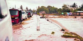
Dar es Salaam. When heavy rains fell across Dar es Salaam this season, they did more than slow traffic. They exposed structural vulnerabilities beneath some of the city’s recently rehabilitated roads.
In Mbagala, where a major corridor was reconstructed alongside the Bus Rapid Transit alignment, sections of the carriageway have again turned into shallow basins after heavy downpours.
In Msasani, Kimweri Avenue, a recently resurfaced stretch that had long suffered from potholes now holds water in familiar depressions.
The pattern has unsettled motorists who assumed rehabilitation meant resolution.
Engineers say the answer lies less in the visible tarmac and more in the invisible systems that govern water.
An expert from the College of Engineering and technology at the University of Dar es Salaam, Dr Elvis Emmanuel, argues that drainage is often present in design drawings, but not always integrated as a complete hydraulic system.
In many cases, he explains, drains are constructed to collect runoff yet lack a clearly engineered and continuous outfall that carries storm water to a river, retention basin or the ocean.
“When rainfall intensifies, water accumulates because it has nowhere else to go,” he said.
Dar es Salaam’s topography complicates the equation. Portions of the city sit barely above sea level, with localized depressions embedded within otherwise elevated corridors.
“If the road profile contains subtle undulations or low points that were not fully corrected during rehabilitation, stormwater settles in these basins,” Dr Emmanuel said.
Once trapped in a depression, it remains until evaporation or gradual seepage relieves it. In the meantime, it weakens the pavement structure.
That structural vulnerability is critical. If rehabilitation focused primarily on milling and overlaying asphalt without redesigning sub-base layers or upgrading drainage capacity, the surface improvement may be cosmetic.
Water infiltration softens the base course, leading to rutting along wheel paths. Those ruts then hold more water, accelerating deterioration in a feedback loop that can undo months of construction within a single rainy season.
Climate is adding a new variable to an already fragile system.
A senior climate change and environment expert, Prof Pius Yanda, says rainfall patterns have shifted markedly.
Prof Yanda is currently the Member of Parliament for Buhigwe constituency and also serves as Vice Chairperson of the Parliamentary Standing Committee on Water and Environment.
“While drainage systems are considered in infrastructure design and government continues investing heavily in road rehabilitation, we have observed that storms are now arriving with greater intensity within shorter time frames,” he said.
The concentration of rainfall, linked to broader climate change trends, means infrastructure designed using historical rainfall averages may be undersized for current extremes.
The result is a mismatch between hydraulic capacity and real-time storm volumes. Even a well-built drain will overflow if peak runoff exceeds its design threshold.
Prof Yanda emphasizes the importance of ensuring that every drainage channel connects to a defined discharge route.
Without a continuous pathway—whether toward rivers or directly to the ocean stormwater accumulates in urban corridors that were never meant to function as reservoirs.
Human activity compounds these engineering pressures. Along busy stretches of the city, commercial centres such as Kariakoo, Mbezi, Manzese and Mbagala, business activity spills into road reserves.
Dr Emmanuel weighed in on human activities, saying that informal driveways alter shoulder gradients.
“Solid waste blocks culverts and side drains. In a rapidly urbanizing city where impermeable surfaces are expanding, runoff volumes are rising even as drainage networks struggle to keep pace,” he said.
Controller and Auditor General (CAG) Mr Charles Kichere had also shed light on the underlying challenges in town planning activities that have exacerbated the current crisis.
The report reveals that informal settlements cover a staggering 70 percent of the general land in Tanzania.
These unplanned settlements lack basic infrastructure and are often located in flood-prone areas, exacerbating the impact of heavy rainfall and putting residents at risk.
Dar es Salaam’s economic pulse depends on roads that perform under stress. Flooded carriageways slow traffic, damage vehicles and erode public confidence in capital-intensive upgrades. More critically, they reveal the gap between infrastructure expansion and infrastructure resilience.
As rainfall patterns evolve and urban density intensifies, the city’s challenge is no longer simply building new roads. It is recalibrating design standards, enforcing construction quality, protecting drainage reserves and ensuring that every drop of water has a planned exit.
Until that systemic alignment occurs, each rainy season will continue to measure the distance between engineering intent and urban reality.
Register to begin your journey to our premium contentSubscribe for full access to premium content