involving villagers has been proven to significant impact on conservation and on better interaction between humans and wild anim
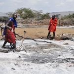
Dar es Salaam. The survival of wild animals is threatened by escalating human-wildlife conflicts. This has been caused by Tanzania’s population growth, which has increased interactions between humans and animals and piled pressure on wildlife at an alarming rate, experts say.
Furthermore, the destruction of the environment has violated the natural wildlife habitats, pushing away even crucial insects such as bees and butterflies, whose role in pollinating crops makes them indispensable actors in human beings’ food chain.
Wildlife areas protected by law, such as national parks and game reserves, are somehow safe for now due to the presence of authorities and paramilitary forces that manage them. On the other hand, wildlife areas that are located beyond protected areas, such as wildlife corridors, animal migration routes, and dispersal areas, remain at the mercy of environmental degraders and poachers. But it doesn’t have to be that way. Most of these wildlife areas are located on village lands, according to Lands Acts Numbers 4 and 5 of 1999.
In other words, wildlife corridors, which enable animals to move from one protected area to another in search of pasturelands, water, and breeding space, fall under village lands.
Tanzania has over 60 wildlife corridors. Involving villagers has been proven to have a significant impact on conservation and on improving interactions between humans and wild animals.
But for this to happen, adequate participatory planning of the use of village lands is essential. Village land use plans Almost all villages have land use plans that guide the use of village lands for the benefit of the majority. The Land Use Planning Act Number 6 of 2007, the National Land Use Framework Plan 2013–2033, the Village Land Act Number 5 of 1999, and other similar legislation have put forward legal mechanisms for village land use plans.
Joseph Olila, a landscape planning and biodiversity specialist working for the USAID Tuhifadhi Maliasili Project, says as far as conservation of wildlife corridors is concerned, land use planning by villages should involve a wide spectrum of stakeholders from the national level to the grassroots.
“We want to see integrated, multisectoral, holistic planning and use of village land not only within the village but between villages,” Mr. Olila told journalists at a workshop organized by the Journalists’ Environmental Association of Tanzania (JET) in Bagamoyo on January 13, 2023.
USAID Tuhifadhi Maliasili (Preserve Natural Resources) is a project that started in 2021 and seeks the conservation of wildlife corridors that enable wild animals to move from one protected area to another in search of food, water, and breeding land. Furthermore, USAID Tuhifadhi Maliasili experts are working with the media through the Journalists’ Environmental Association of Tanzania to raise awareness of conservation issues among all key stakeholders. John Noronha, Monitoring and Evaluation Manager at RTI, a USAID contractor implementing the USAID Tuhifadhi Maliasili Project, says land use plans will enable villagers to determine which part of the village land should be used for which activity.
This will ensure that the part of land that falls under conservation is allocated only for those economic activities that reduce conflicts with wild animals and maximize the benefits of the involved land to the villagers, Noronha adds.
“Tanzania has enough land to enable all required farming, grazing, building, and other community activities in areas away from the human-wildlife interface, though this requires careful and participatory land use planning and management,” Mr. Noronha notes.
Joint and participatory land use plans But because wildlife corridors can extend over hundreds of kilometers, they occupy the land of many villages across districts.
For that matter, land use plans involving wildlife corridors should be carried out jointly by several villages in what is called “joint land use plans,” according to Mr. Olila.
The aim is to have the same use of the pieces of land that are located at wildlife corridors by neighbouring villages.
But the planning should also bring together government officials from all key departments, such as lands, agriculture, forestry, wildlife, and tourism, to see to it that all development projects take into consideration provisions for wildlife in the area, Mr. Olila adds.
“When we say multisectoral, we mean that planning should also include the private sector, especially investors who have economic projects in the concerned rural areas,” Mr. Olila notes.
In setting up land use plans, it is essential for the process to be as participatory as possible, and villages should follow all six steps for participatory village land use planning required by law.
The first step is preparation at the district level.
This is important as it sets the stage for the next steps, namely participatory rural appraisal and mapping of existing village land uses.
The fourth step is the unveiling of the village land use plan itself. Many villages usually end up going through the process when they get the land use plan.
But this makes it difficult to regulate the use of land. It, therefore, calls for the next step, which is village land administration.
This is followed by village land use management and consolidation. Completing all the steps in a participatory manner and when the process is conducted jointly with other villages it gives an opportunity for the creation of the participatory district land use framework plan, which can provide the possibility for landscape planning. “Landscape planning and management enable coordination and regulation of the use of wildlife corridors among various villages to help contain illegal logging, preserve sources of water, and manage conflicts over resource uses, especially between farmers and livestock keepers,” says Mr. Olila.