With the signing of the agreement between the World Bank and Finance Ministry for the bridge construction, the flooding to the residents of Jangwani area in Dar es Salaam will soon be history
Dar es Salaam. Last week, the Ministry of Finance and the World Bank signed a $200 million (Sh463.98 billion) loan agreement to implement the Msimbazi Basin Project to mark a concrete fulfilment of President Samia Suluhu Hassan’s desire since her days as Vice President.
Also signed between the Finance minister, Dr Mwigulu Nchemba and the World Bank’s country director, Mr Nathan Belete last week was a $341 million (about Sh791 billion) additional financing package for the Tanzania Rural Electrification Expansion Programme.
The Tanroads’ chief executive officer Mr Rogatus Mativila said in Dar es Salaam last week that apart from elevating the bridge to put the floods on check, the project would also include non-motorised transport, with dedicated lanes for the Bus Rapid Transit (BRT), mixed traffic lane, cycling path, green zone, walkway, and hard shoulder.
“The Jangwani Bridge and adjacent BRT Bus Depot have become increasingly prone to flooding due to sedimentation and waste that clog the bridge and result in flash floods that shut down the transit system and damage the BRT buses,” Mr Mativila said last week.
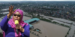
The signing however, reminds pundits of the President’s role in an effort to find a lasting solution to flooding in Dar es Salaam during her days as Vice President with the environment falling within her docket.
It was her quest to eliminate flooding in the commercial capital that in January, 2018 a coherent participatory process to beget the Msimbazi Plan, was initiated.
Known as the “Charrette”, the coherent participatory process –which went until August 2018 involved over 200 people from 59 institutions and communities, World Bank documents show.
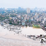
Though in April of the same year, rains only displaced thousands of people in Dar es Salaam, city residents would still remember how the severe record of floods killed 42 people and displaced over 10,000 more in December last year.
In a January, 2019 joint document by the World Bank and the President’s Office (Regional Administration and Local Governments), the parties say, it was in response to a call by the then Vice President Hassan to pragmatically address the recurrent flood risk in Dar es Salaam that the Msimbazi Opportunity Plan was developed through a participatory design process, known as a ‘Charrette’. In the preliminary stages of the Msimbazi Charrette process, stakeholders from the highest levels of the government to the grassroots of the community, from civil society to private sector, came together to determine how to best address the multi-faceted challenges posed by the recurrent flooding in the Msimbazi.
In the course of their deliberations, they came to realise that the Msimbazi River had been overwhelmed by the intense pressures that unplanned and unchecked urbanisation has put on natural ecosystems over the last decades. Historically, a large part of the upper and middle basin was natural forestland and wild bush where flood events and sediment transport contributed to the fertility of the area.
According to the document, the rural-urban migration in Tanzania had accelerated since the 1970’s, with high growth rates in Dar es Salaam.
“Over the last fifty years, this urbanization pressure has gradually reduced the
water retention capacity in the wider basin and has created various blockages for natural water
discharge,” the document reads, saying the situation is what resulted in flooding in 2009, 2010, 2011, 2014, 2015, 2017 and 2018.
According to Mr Mativila, the bridge design and scope of proposed construction phase dredging were carefully considered based on hydrodynamic modeling results to analyze flood hazards, river bathymetry, a digital elevation model of the lower Msimbazi River Basin, and satellite imagery including vegetation and sedimentation patterns.