Arusha. Tanzania is set to attract wider global attention in geological research after scientists confirmed that Mount Meru contains one of the largest volcanic debris avalanche deposits ever recorded. The discovery highlights the mountain’s scientific significance and strengthens its potential as a major geotourism destination.
Conservation officials and researchers say the extensive debris deposits at the base of the mountain were formed about 9,000 years ago following a catastrophic volcanic collapse. The event reshaped the surrounding terrain and left behind a vast field of geological material that remains visible today.
The Conservation Officer responsible for tourism at Arusha National Park, Mr Jerome Boniface Ndazi, said the ancient avalanche created a landscape marked by hills and distinctive rock formations.
He explained that scientific studies indicate the materials were deposited during a major eruption and structural collapse of the Meru volcano thousands of years ago.
Mr Ndazi added that the same geological processes played a major role in shaping several prominent features within the park. These include Ngurdoto Crater, the Momella Lakes and Tululusia Waterfall, all of which remain among the park’s leading tourist attractions.
According to conservation officials, the vast debris landscape presents valuable opportunities for geotourism development. The site is expected to attract scientists, students and international visitors with an interest in volcanic formations and earth science. Authorities have also identified the location as a potential candidate for recognition as a UNESCO Global Geopark.
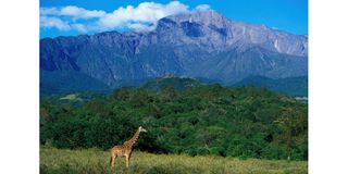
Mount Meru is a dormant volcano and the second-highest peak in Tanzania after Mount Kilimanjaro. Rising to 4,565 metres above sea level, it ranks among Africa’s most prominent volcanic mountains. The volcano lies within the Northern Tanzanian Divergence Zone, which forms part of the eastern branch of the East African Rift System.
One of the mountain’s most recognisable features is a large horseshoe-shaped scar on its eastern side. Scientists believe this scar resulted from a massive collapse associated with the ancient Momella debris avalanche.
Recent studies that combined remote sensing technology with detailed field mapping have provided fresh insights into the structure and distribution of the deposits. Researchers identified comp
lex terrain patterns that include hummocks, ridges, lobes, grabens and shear zones. These features point to a complicated sequence of movement and deposition during the collapse.
Scientists also identified different geological layers, including both solidified and fragmented rock materials. Findings suggest the collapse involved a volume exceeding 20 square kilometres.
Debris is believed to have spread across approximately 1,250 square kilometres, extending as far as the foothills of Mount Kilimanjaro.
Further evidence indicates that water played an important role in the avalanche’s movement.
Researchers found signs of a water-saturated base layer, which likely increased the speed and reach of the flowing material during the event.
The research was conducted by an international team of scientists from institutions including Vrije Universiteit Brussel, Université Clermont Auvergne and Rhodes University.
Geologist Mr Roger Scoon said the collapse of the Meru caldera can be compared to the 1980 Mount St. Helens eruption, although he noted that the Tanzanian event was significantly larger in scale.
He added that the avalanche transformed the surrounding landscape and contributed to the creation of the Momella Lakes. Today, these lakes serve as important habitats for migratory birds and support a wide range of wildlife.
The montane forests that cover Mount Meru’s slopes remain ecologically rich. They sustain diverse wildlife and bird species, further strengthening the mountain’s environmental importance and its value to Tanzania’s tourism sector.