Harnessing data to sustain Katuma River’s ecosystem
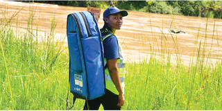
Water Resources Manager Nasra Nassoro at the Lake Rukwa Basin Water Board (LRBWB).
By Asha Msoka and Bruno Richard
In the soft morning light along the Katuma River in western Tanzania, Nasra Nassoro stands knee-deep in the flowing water, calmly directing her team as they lower a flow monitor into place.
The device hums gently, recording the river’s speed, depth, and volume.
For Nasra, Water Resources Manager at the Lake Rukwa Basin Water Board (LRBWB), this is more than routine fieldwork. It is a moment of quiet triumph.
“I have worked here as a hydrologist for 15 years,” Nasra reflects.
“This area has unique potential in terms of biodiversity richness, but we struggled to manage our water resources across the Katuma catchment and maximise its benefits.
The IKI Katuma project has completely transformed our ability to understand and make informed decisions,” she adds.
The Katuma River is the beating heart of one of Tanzania’s most ecologically diverse and economically vital regions.
Rising in the Mwese and Mpanda Mountains on the Ufipa Plateau, it winds through Katavi National Park, one of the country’s most untouched and wildlife-rich protected areas, before emptying into Lake Rukwa.
Seasonal floods recharge the ecosystem and sustain habitats that support Tanzania’s growing tourism sector.
Beyond the park, the Katuma supports over one million people who rely on it for clean drinking water, small-scale irrigation, livestock watering, fisheries, and everyday enterprises.
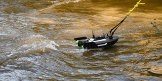
The RS5 Acoustic Doppler Current Profiler positioned in the Katuma River to collect high-resolution flow measurements for water resources assessment.
In recent years, the catchment has also become a strategic national food basket, playing a key role in food security and export earnings.
However, the river’s significance has also brought growing pressure. Rapid agricultural expansion, illegal water abstraction, widespread deforestation, informal fishing dams, and artisanal gold mining have disrupted natural flows, increasing sedimentation and degrading water quality and quantity.
These pressures have intensified competition among water users and have threatened the park’s wildlife.
For years, the Lake Rukwa Basin Water Board’s faced challenges due to limited access to reliable data, hampering effective river management.
Monitoring stations were sparse, and sections of the river lacked measurements altogether.
Field visits were often time-consuming and occasionally dangerous. Consequently, water permits, allocations, and enforcement decisions were often reactive and based on incomplete information.
“Without accurate data, estimating available water or safe allocation levels felt like guesswork,” Nasra explains.
Turning data into better water management
A turning point came in 2024 with the launch of the International Climate Initiative (IKI)-funded Katuma project, implemented by SNV in partnership with GIZ, the Lake Rukwa Basin Water Board, and local stakeholders.
From the earliest discussions, Nasra and her colleagues helped shape the initiative, ensuring it addressed real on-the-ground needs.
After researching technologies suited to the catchment’s conditions, SNV selected an Acoustic Doppler Current Profiler (ADCP), a portable device that delivers accurate discharge data, following its research into robust technologies suited to the catchment’s conditions.
Crucially, the project focused on building users’ skills, confidence, and independence.
Nasra and her team of more than 10 hydrologists received intensive hands-on training and ongoing mentoring, covering the full data lifecycle: field protocols, collection, storage, analysis, interpretation, reporting, and dissemination.
For the first time, the Board gained access to reliable, real-time hydrological information.
Teams can now update rating curves, track seasonal flow patterns, and generate evidence to guide water abstraction permits, flood-risk planning, and infrastructure investments.
The improved data also allows them to anticipate dry-season shortages, reduce conflicts between upstream irrigators and downstream needs, guide farmers toward more sustainable practices, and safeguard environmental flows essential for Katavi National Park’s ecosystem.
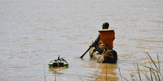
A field assistant paddles a canoe while towing the RS5 ADCP/hydrological instrument across the lake to measure water depth and volume.
Community becomes steward of the river
Nasra played a pivotal mentoring role throughout. She coordinated monitoring schedules across the catchment, organised field teams, and ensured colleagues were trained in both data handling and communication.
Over time, Nasra’s own leadership grew alongside her technical expertise, leading to her well-earned promotion to Water Resources Manager.
The benefits ripple outward to communities through trained gauge readers like Hilary Daudi Kapenegele, a member of the Katuma Water Users Association.
“I never fully realised how this data would also benefit us directly, at community and individual levels, as farmers and livestock keepers,” Kapenegele shares, adding: “Now we understand its value, and we discuss findings in village meetings to decide on necessary actions,”
The project is also developing accessible visual tools, such as clear charts, dashboards, and simple graphics that make complex hydrological information understandable to everyone, including schoolchildren.
Kapenegele notes proudly: “We hear that the project will create appealing visuals so that even a second-grade child can grasp the water situation in the Katuma River. I feel proud to be a gauge reader for our village.”
These efforts are cultivating a culture of shared stewardship. Communities are becoming informed partners in managing the catchment rather than passive recipients of regulations.
A replicable model ready for water basins
The Katuma experience was intentionally designed as a replicable model. By investing in local institutions and professionals like Nasra, the project offers an approach that could be adapted Tanzania’s nine other water basins.
Reliable data, skilled teams, and engaged communities provide a strong foundation for sustainable management anywhere.
Challenges remain
Climate variability, population growth, and increasing demand continue to pressure the river.
Nasra remains realistic: “Katuma has improved significantly. We are not where we once were, but not yet where we aim to be. More investment is needed, but now we have the evidence and confidence in advocating for it.”
The IKI Katuma project demonstrates the power of targeted, people-centred support. Modern equipment opens possibilities, but it is training, mentoring, and leadership development that turns tools into enduring change.
As Tanzania confronts escalating water challenges, Nasra’s story offers both inspiration and a clear pathway toward integrated, evidence-based water management, fair water allocation, flood and drought resilience, and long-term climate adaptation.
This project is supported by the International Climate Initiative (IKI) of the Federal Government of Germany. Within the Federal Government, the IKI is anchored in the Federal Ministry for the Environment, Climate Action, Nature Conservation and Nuclear Safety (BMUKN). Selected individual projects are also the responsibility of the Federal Foreign Office (AA).