Mapping our way to resilience: How Tanzania is redrawing the future of sustainability in East Africa

By Innocent Maholi

There is a particular kind of intelligence that lives in communities long before it reaches a policy document or a national strategy. It lives in the memory of an elder who remembers where the floodwaters rose highest in 1998. It lives in the observations of a market woman who knows which roads become impassable the moment the rains begin.

In the nearly ten years since we founded OpenMap Development Tanzania, this has been the lesson at the heart of everything we do: the knowledge to solve our hardest problems is rarely absent from our communities. What is often absent is the infrastructure to capture that knowledge, share it, and act on it at scale.

That gap is precisely what we set out to close when we established OMDTZ in 2017, and it is why I believe our work carries lessons for anyone thinking seriously about sustainability, water security, food security, climate action and health across East Africa today.

Since our founding, we have built something I am genuinely proud of: a growing, organised community of Tanzanian mappers who use open-source tools, principally OpenStreetMap, to fill in the geographic blanks that so often stand between a community and effective public response. Our vision was always a vibrant, united OpenStreetMap community contributing to national and global development goals. It might sound modest on paper.

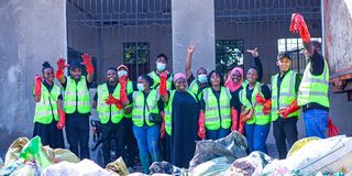
In practice, it has meant creating detailed, freely accessible datasets that help decision-makers understand where waste management is failing, where flood risk is concentrated, and where infrastructure gaps are putting lives at risk. It has meant training government offices, including the President's Office Regional Administration and Local Government (PORALG), along with universities and civil society groups, in how to generate and use open geospatial data responsibly.

I want to be precise about why this matters, because "open data" can sound abstract until you see it in use. A flood risk map built by a community, using knowledge that community actually holds, is not the same as a map imposed from above. It reflects the lived contours of vulnerability.

It tells a district engineer exactly where drainage needs reinforcing before the rains arrive, rather than after the damage is done. It gives a health worker a clearer picture of which neighbourhoods will be cut off when the roads flood, so that medicine and emergency response can be pre-positioned.

This is climate adaptation built from the ground up, and it is the model my team and I have championed since day one, because we have seen firsthand that it produces more durable outcomes than solutions designed without community participation.

That is also why receiving the 2025 Zayed Sustainability Prize, in the Climate Action category, felt like such a profound moment for us. We were thrilled and deeply honoured by the recognition.

The prize, established as a tribute to the legacy of Sheikh Zayed bin Sultan Al Nahyan, has become one of the most consequential accolades in global sustainability, and being recognised as a Tanzanian, community-rooted organisation sent an important signal, not just to us, but to our peers across the continent.

It said that African-led, African-designed solutions to climate risk are not peripheral to the global sustainability conversation. They are central to it.

The impact since that win has been tangible for us as an organisation. The one million US dollar prize fund has allowed us to extend our community mapping initiatives into additional flood-prone regions, including Morogoro and Pwani, areas where seasonal flooding has long disrupted livelihoods, education and access to health services.

We have expanded our use of drone mapping technology, giving communities a faster, more accurate way to visualise risk before disaster strikes rather than after. Our capacity-building programmes have deepened, strengthening the pipeline of young Tanzanian mappers and data specialists who will carry this work forward long after we are gone.

And crucially, we have been able to deepen partnerships with local government and international organisations, moving from isolated projects toward the kind of sustained, systems-level engagement that genuine resilience requires.

What strikes me most, as someone who has spent years building an organisation around the belief that data should belong to the people who generate it, is that our growth trajectory reflects something I think about constantly: sustainable development is not a single sector's responsibility. Water security, food security, health and climate action are interlocking systems. A flood map is also a health intervention.

A dataset on waste management is also an economic empowerment tool, particularly for the women who so often bear the burden of managing household and community resources under climate stress. When we invest in the infrastructure of information, we are investing simultaneously in all of these domains.

The scale of interest in this kind of work is itself instructive, and it tells me we are not alone in this belief. This year, the Zayed Sustainability Prize closed its most recent submission cycle having received a record 10,233 entries from 177 countries, a rise of roughly 32 percent over the previous cycle, and the highest participation in the prize's eighteen-year history.

More than two-thirds of those submissions came from developing and emerging economies.

This tells us something important: the appetite for community-rooted, locally designed sustainability solutions is not shrinking. It is accelerating, and organisations from across Africa, Asia and Latin America are stepping forward with credible, scalable models of their own.

Tanzania, and East Africa more broadly, has an opportunity here that we cannot afford to squander. We at OMDTZ have tried to demonstrate that open data, built by and for communities, can transform how governments plan, how disasters are anticipated, and how resources reach the people who need them most.

We have a growing network of young mappers who understand their own geography better than any external consultant ever could. And we now have global recognition affirming that this approach works.

The task ahead, for us and for organisations like ours, is to ensure that this recognition translates into sustained investment, not just in mapping technology, but in the people, institutions and policies that allow this knowledge to be used well.

As someone who has built this organisation from the ground up, I can say with confidence: the map is only the beginning. What we do with it, and who we build it with, will determine whether Tanzania's sustainability transformation becomes a lasting one.

Innocent Maholi is Executive Director, OpenMap Development Tanzania