The first drones were built during the First World War and were steered using radio control. In recent years the popularity of civilian drones has increased, and most drones are used for mapping, farming and for operations after natural disasters.
PHOTOS ANNE KIDMOSE.
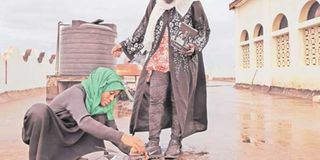
Khadija Ali Abdulla sits in a room full of drones. By her feet is a white one, buzzing around her, and a black drone with large wings rests on the table next to her.
The small, buzzing one is merely a toy, she explains, as it bounces across the room like a confused bumblebee. However, the rest of them have a more serious purpose.
“We don’t just use drones for fun, but for planning our future. We can use images from drones to design a new city which is not so overpopulated, and we can use images to prove to city planners that they need to shift people from an area where they die of cholera,” says Khadija Ali.
As an intern at Zanzibar Mapping Initiative, the 27-year-old programmer is part of a team of drone pilots and IT-specialists who have mapped Unguja Island using drones.
The initiative is a collaboration between The State University of Zanzibar (SUZA), the Zanzibari government, Costech and the World Bank which seeks to obtain high-resolution maps that can assist in mitigating floods.
Now, Khadija is a skilled drone pilot, and she coaches fellow students on how to maneuver the bird-like robots safely.
“People want to change their communities to the better, and this is a project that can do it. Now, we map areas that are prone to cholera and we survey places where there is always flooding,” says Khadija who completed her bachelor’s degree in IT and Application Management at SUZA last year.
As a woman having lived in Zanzibar all her life, Khadija is hardly the archetypical drone pilot. During the last two years, she has spent most of her time with drones – either programming at SUZA or flying over the archipelago. It has raised a few eyebrows.
“In our culture, a woman should take care of the children and the house. But working with the initiative, I was gone from 6am to 8pm. So, people started asking what I was doing,” she recalls.
A new tech generation
Her family and her husband, however, are understanding and supportive of her career choice. She believes that a firm self-confidence is what it takes to succeed as a woman in a technological field.
“If you want to become someone, you need to respect yourself,” she says.
Khadija is not the only programmer to have discovered the potential of drones. Recently, East Africa has seen a rise of tech-entrepreneurs who use drones for medical deliveries and data collection of densely populated areas or fragile ecosystems. In Rwanda, the health ministry has joined forces with the American drone company Zipline in a bid to transport blood to the country’s remote hospitals, and in Tanzania, the robots provide images to alleviate conflicts over land.
One of the first Tanzanians to explore the use of drones for social good was 45-year-old Frederick Mbuya, who runs his own IT-consultancy, Uhurulabs. Three years ago, he bought his first consumer drone and quickly realized that it could be utilized as a tool to assist the development of Dar es Salaam.
“I found out that the community mapping project Ramani Huria didn’t have any aerial imagery, and a satellite image is quite unclear and old. I thought it might work better with drones,” he says.
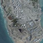
Soon, Frederick was viewing Dar es Salaam through the camera fitted on a drone’s stomach. The aerial images helped construct a map of the city’s most flood prone areas much faster than anyone could do on ground.
“Only three per cent of Africa has been mapped to a local scale. Drones have the potential to change that, and it has already started in Dar es Salaam and all of Zanzibar,” says Frederick, who works as a consultant at Ramani Huria.
Mapping land rights
A detailed map also makes it possible to secure land titles to especially small-scale farmers in rural Tanzania, Frederick explains. When the Ministry of Lands, Housing and Human Settlements heard of the drone footage, Frederick was hired for a large-scale land tenure project. In collaboration with Costech, he photographed farm land and provided maps that can prevent clashes over land rights.
A cardboard drone
While drones are utilized as tools for monitoring and mapping purposes, the use of the robots as means of transportation is still largely unexplored territory. Next year, Tanzania will host the region’s first expo on drones for delivery, The Lake Victoria Challenge, which will gather stakeholders from across East Africa to test the potential of drones as an infrastructure solution in isolated communities.
“When it comes to cargo, we are delivering to places where it has been very difficult to get to. This way, we get drone specialists, and that’s why it is so important that the work is done by Tanzanians,” Frederick says.
At Ramani Huria’s drone laboratory in Dar es Salaam, 24-year-old Bornlove Ntikha looks absorbed as he connects his laptop with a flight controller strapped on a piece of cardboard. This is his new drone.
“I want to know how to fly and construct drones. That way, I can give on my knowledge and we won’t need support from outside the country. We want to decentralize the industry,” says Bornlove, who has a bachelor’s degree in Community Development.
His homemade drone still lacks its wings, but Bornlove places it on the lawn and steadily moves further away with a remote-control to test its connection. He returns with a satisfied look on his face – the cardboard drone works.
Sensible regulation
While Bornlove is pleased with his drone, the use of new technologies also brings new challenges. Although drones can be utilized for social good, regulation of the technology is important, argues Policy Researcher at the American think tank RAND, Shira Efron. She has been researching the use of drones in African agriculture.
“First of all, sensible regulation is needed. As of September 2017, only 26 per cent of countries in Africa had UAV regulation in place. While regulation is usually behind technological advancements it is important that it does not stall development, push away investment and pose a hurdle to job creation. It’s okay to be careful but a move is required,” she writes in an email.
IT officer at Costech, Mr Alfred Nyoni, explains that there are regulations in place in Tanzania, although few are aware of them.
“You have to inform the local community before you fly a drone, and you need a permit as well. This goes for all drones, and I think that’s fair. You wouldn’t drive a car without a driver’s license either,” he says.
Back in Zanzibar, Khadija Ali Abdulla is fully aware that drones might seem frightening to some. Flying over the islands, some locals mistake her drone for a different object. “Some people think it is a bomb and that you work with the military. When it lands, they come out screaming and they call the police. Then we talk to them and make them touch it, and they see that it is a device,” she says.
Unmanned Aerial Vehicle (UAV)Unmanned Aerial Vehicles, popularly named drones, are aircraft with no passengers onboard. The first drones were built during the First World War and were steered using radio control. In the 1930s the British built a range of pilot-less aircraft to be used in military training. Among these, was the Queen Bee model which inspired the use of the term ‘drone’. Today, drones are still used for military purposes and particularly for surveillance of inaccessible areas and more notoriously as weapons. However, in recent years the popularity of civilian drones has increased, and most drones are used for purposes such as mapping, farming and for operations after natural disasters.
While mapping Zanzibar and Dar es Salaam, the pilots used drones weighing 700 grams and flying about 90 meters above ground level. The drones have a camera attached which captures about 700 images per square kilometre. Afterwards, the images are processed using specialized software. (Sources: Imperial War Museum, Zanzibar Mapping Initiative)